Weather Alert in North Carolina
Special Weather Statement issued February 5 at 7:05PM EST by NWS Wilmington NC
AREAS AFFECTED: Robeson; Bladen; Columbus; Inland Pender; Coastal Pender; Inland New Hanover; Coastal New Hanover; Inland Brunswick; Coastal Brunswick; Marlboro; Darlington; Dillon; Florence; Marion; Williamsburg; Coastal Horry; Inland Georgetown; Coastal Georgetown; Central Horry; Northern Horry
DESCRIPTION: Standing water from the recent rainfall and any leftover melting snow will result in patchy black ice along or across area roadways and thoroughfares as temperatures drop to and below 32 later this evening, and into the 20s overnight. Icy spots could form on paved surfaces such as bridges and overpasses, primary and especially less traveled secondary roads, parking lots, sidewalks and driveways. Black ice is difficult to see and distinguish from dry surfaces. The deceptive nature of black ice can catch you unaware while you are driving or walking, causing you to lose control of your motor vehicle or for one to slip and fall.
INSTRUCTION: If you plan to drive or walk, remain alert for those slick spots. Slow your driving speed and use care when walking on sidewalks, driveways or across parking lots. Slips and falls constitute a leading cause of injuries during the winter weather season.
Want more detail? Get the Complete 7 Day and Night Detailed Forecast!
Current U.S. National Radar--Current
The Current National Weather Radar is shown below with a UTC Time (subtract 5 hours from UTC to get Eastern Time).

National Weather Forecast--Current
The Current National Weather Forecast and National Weather Map are shown below.

National Weather Forecast for Tomorrow
Tomorrow National Weather Forecast and Tomorrow National Weather Map are show below.

North America Water Vapor (Moisture)
This map shows recent moisture content over North America. Bright and colored areas show high moisture (ie, clouds); brown indicates very little moisture present; black indicates no moisture.

Weather Topic: What is Sleet?
Home - Education - Precipitation - Sleet
 Next Topic: Snow
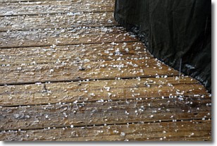
Sleet is a form of precipitation in which small ice pellets are the primary
components. These ice pellets are smaller and more translucent than hailstones,
and harder than graupel. Sleet is caused by specific atmospheric conditions and
therefore typically doesn't last for extended periods of time.
The condition which leads to sleet formation requires a warmer body of air to be
wedged in between two sub-freezing bodies of air. When snow falls through a warmer
layer of air it melts, and as it falls through the next sub-freezing body of air
it freezes again, forming ice pellets known as sleet. In some cases, water
droplets don't have time to freeze before reaching the surface and the result is
freezing rain.
Next Topic: Snow
Weather Topic: What are Stratocumulus Clouds?
Home - Education - Cloud Types - Stratocumulus Clouds
 Next Topic: Stratus Clouds
Stratocumulus clouds are similar to altocumulus clouds in their
fluffy appearance, but have a slightly darker shade due to their additional mass.
A good way to distinguish the two cloud types is to hold your hand out and measure
the size of an individual cloud; if it is the size of your thumb it is generally
an altocumulus cloud, if it is the size of your hand it is generally a
stratocumulus cloud.
It is uncommon for stratocumulus clouds to produce precipitation, but if they do
it is usually a light rain or snow.
Next Topic: Stratus Clouds
Current conditions powered by WeatherAPI.com


