Weather Alert in Alaska
High Wind Warning issued February 24 at 3:58PM AKST until February 26 at 9:00AM AKST by NWS Anchorage AK
AREAS AFFECTED: Thompson Pass
DESCRIPTION: * WHAT...North winds 40 to 65 mph with gusts up to 85 mph expected. Wind chills dropping to 45 below Wednesday night. * WHERE...Thompson Pass. * WHEN...From 3 AM Wednesday to 9 AM AKST Thursday. * IMPACTS...High winds may move loose debris, damage property, and cause power outages. Travel will be difficult. Blowing snow due to high winds will reduce visibilities to one half mile or less at times. The dangerously cold wind chills as low as 40 below zero could cause frostbite on exposed skin in as little as 10 minutes. * ADDITIONAL DETAILS...North to northeast winds will rapidly strengthen late Tuesday afternoon through Tuesday night, then peak Wednesday through Wednesday night. As winds first develop, freshly fallen snow will easily blow around, leading to near-blizzard conditions at times. As snow becomes scoured out, visibilities should improve. Winds will very slowly diminish Thursday through Friday.
INSTRUCTION: Winds this strong can make driving difficult, especially for high profile vehicles. Use extra caution.
Want more detail? Get the Complete 7 Day and Night Detailed Forecast!
Current U.S. National Radar--Current
The Current National Weather Radar is shown below with a UTC Time (subtract 5 hours from UTC to get Eastern Time).

National Weather Forecast--Current
The Current National Weather Forecast and National Weather Map are shown below.

National Weather Forecast for Tomorrow
Tomorrow National Weather Forecast and Tomorrow National Weather Map are show below.

North America Water Vapor (Moisture)
This map shows recent moisture content over North America. Bright and colored areas show high moisture (ie, clouds); brown indicates very little moisture present; black indicates no moisture.

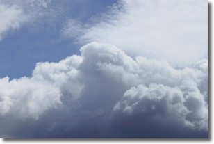
Weather Topic: What are Nimbostratus Clouds?
Home - Education - Cloud Types - Nimbostratus Clouds
 Next Topic: Precipitation
A nimbostratus cloud is similar to a stratus cloud in its formless,
smooth appearance. However, a nimbostratus cloud is darker than a stratus cloud,
because it is thicker.
Unlike a stratus cloud, a nimbostratus cloud typically brings with it the threat
of moderate to heavy precipitation. In some cases, the precipitation may evaporate
before reaching the ground, a phenomenon known as virga.
Next Topic: Precipitation
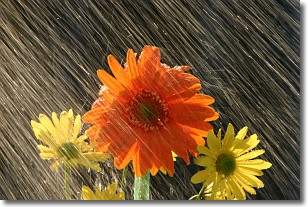
Weather Topic: What is Rain?
Home - Education - Precipitation - Rain
 Next Topic: Shelf Clouds
Precipitation in the form of water droplets is called rain.
Rain generally has a tendency to fall with less intensity over a greater period
of time, and when rainfall is more severe it is usually less sustained.
Rain is the most common form of precipitation and happens with greater frequency
depending on the season and regional influences. Cities have been shown to have
an observable effect on rainfall, due to an effect called the urban heat island.
Compared to upwind, monthly rainfall between twenty and forty miles downwind of
cities is 30% greater.
Next Topic: Shelf Clouds
Current conditions powered by WeatherAPI.com


