Weather Alert in Florida
Severe Thunderstorm Warning issued March 16 at 10:30AM EDT until March 16 at 11:30AM EDT by NWS Tallahassee FL
AREAS AFFECTED: Bay, FL; Calhoun, FL; Gadsden, FL; Gulf, FL; Jackson, FL; Liberty, FL
DESCRIPTION: SVRTAE The National Weather Service in Tallahassee has issued a * Severe Thunderstorm Warning for... Southeastern Jackson County in the Panhandle of Florida... Gulf County in the Panhandle of Florida... Southeastern Bay County in the Panhandle of Florida... Calhoun County in the Panhandle of Florida... Gadsden County in Big Bend Florida... Liberty County in Big Bend Florida... * Until 1130 AM EDT/1030 AM CDT/. * At 1030 AM EDT/930 AM CDT/, severe thunderstorms were located along a line extending from 7 miles northwest of Blountstown to 23 miles southwest of Tyndall Air Force Base, moving east at 45 mph. HAZARD...60 mph wind gusts. SOURCE...Radar indicated. IMPACT...Expect damage to roofs, siding, and trees. * Locations impacted include... Quincy, Havana, Blountstown, Midway, Port St. Joe, Mexico Beach, Stonemill Creek, Chattahoochee, Greensboro, Tyndall Air Force Base, White City, Orange, Wewahitchka, Sneads, Gretna, Bristol, Grand Ridge, Altha, Rock Bluff, and Honeyville.
INSTRUCTION: Remain alert for a possible tornado! Tornadoes can develop quickly from severe thunderstorms. If you spot a tornado go at once into the basement or small central room in a sturdy structure. For your protection move to an interior room on the lowest floor of a building. A Tornado Watch remains in effect until noon EDT/1100 AM CDT/ for the Panhandle of Florida. A Tornado Watch also remains in effect until 200 PM EDT/100 PM CDT/ for Big Bend and the Panhandle of Florida.
Want more detail? Get the Complete 7 Day and Night Detailed Forecast!
Current U.S. National Radar--Current
The Current National Weather Radar is shown below with a UTC Time (subtract 5 hours from UTC to get Eastern Time).

National Weather Forecast--Current
The Current National Weather Forecast and National Weather Map are shown below.

National Weather Forecast for Tomorrow
Tomorrow National Weather Forecast and Tomorrow National Weather Map are show below.

North America Water Vapor (Moisture)
This map shows recent moisture content over North America. Bright and colored areas show high moisture (ie, clouds); brown indicates very little moisture present; black indicates no moisture.

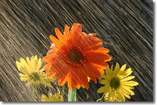
Weather Topic: What is Rain?
Home - Education - Precipitation - Rain
 Next Topic: Shelf Clouds
Precipitation in the form of water droplets is called rain.
Rain generally has a tendency to fall with less intensity over a greater period
of time, and when rainfall is more severe it is usually less sustained.
Rain is the most common form of precipitation and happens with greater frequency
depending on the season and regional influences. Cities have been shown to have
an observable effect on rainfall, due to an effect called the urban heat island.
Compared to upwind, monthly rainfall between twenty and forty miles downwind of
cities is 30% greater.
Next Topic: Shelf Clouds
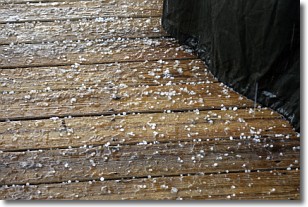
Weather Topic: What is Sleet?
Home - Education - Precipitation - Sleet
 Next Topic: Snow
Sleet is a form of precipitation in which small ice pellets are the primary
components. These ice pellets are smaller and more translucent than hailstones,
and harder than graupel. Sleet is caused by specific atmospheric conditions and
therefore typically doesn't last for extended periods of time.
The condition which leads to sleet formation requires a warmer body of air to be
wedged in between two sub-freezing bodies of air. When snow falls through a warmer
layer of air it melts, and as it falls through the next sub-freezing body of air
it freezes again, forming ice pellets known as sleet. In some cases, water
droplets don't have time to freeze before reaching the surface and the result is
freezing rain.
Next Topic: Snow
Current conditions powered by WeatherAPI.com


