Weather Alert in Montana
Red Flag Warning issued March 24 at 12:10PM MDT until March 25 at 9:00PM MDT by NWS Billings MT
AREAS AFFECTED: Gallatin National Forest; Wheatland County/Sweet Grass County; Stillwater County
DESCRIPTION: The National Weather Service in Billings has issued a Red Flag Warning...which is in effect from noon to 9 PM MDT Wednesday. The Fire Weather Watch is no longer in effect. * IMPACTS: Low humidities, unseasonably warm temperatures, strong gusty winds, and wind shift with a cold front will create erratic fire behavior and the potential for new fire starts. * AFFECTED AREA: In South Central MT Fire Zones...123...124...125. For Zone 123, the worst conditions will impact the lower elevations where grasses remain dead or dry. * COUNTIES AFFECTED: In Central MT...Wheatland. In South Central MT...Park...Stillwater...Sweet Grass. In Southwest MT...Gallatin. * COLD FRONT: The front will move in from the north, with passage timing forecast between 3 PM and 9 PM MDT Wednesday. Expect the districts along the Beartooth Foothills to see frontal arrival the latest. This will bring an end to the gusty conditions and shift winds from the west to the north-northeast. Light showers are possible behind the front, although the chance of a wetting rain is low. * WIND: West 25 to 35 mph with gusts up to 60 mph. Strongest from Livingston to Big Timber and north through Harlowton. * HUMIDITY: As low as 15 percent. * TEMPERATURES: Up to 75 degrees.
INSTRUCTION: A Red Flag Warning means that critical fire weather conditions are either occurring now, or will shortly. A combination of strong winds, low relative humidity, and warm temperatures can contribute to extreme fire behavior.
Want more detail? Get the Complete 7 Day and Night Detailed Forecast!
Current U.S. National Radar--Current
The Current National Weather Radar is shown below with a UTC Time (subtract 5 hours from UTC to get Eastern Time).

National Weather Forecast--Current
The Current National Weather Forecast and National Weather Map are shown below.

National Weather Forecast for Tomorrow
Tomorrow National Weather Forecast and Tomorrow National Weather Map are show below.

North America Water Vapor (Moisture)
This map shows recent moisture content over North America. Bright and colored areas show high moisture (ie, clouds); brown indicates very little moisture present; black indicates no moisture.

Weather Topic: What is Sleet?
Home - Education - Precipitation - Sleet
 Next Topic: Snow
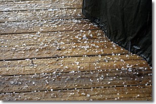
Sleet is a form of precipitation in which small ice pellets are the primary
components. These ice pellets are smaller and more translucent than hailstones,
and harder than graupel. Sleet is caused by specific atmospheric conditions and
therefore typically doesn't last for extended periods of time.
The condition which leads to sleet formation requires a warmer body of air to be
wedged in between two sub-freezing bodies of air. When snow falls through a warmer
layer of air it melts, and as it falls through the next sub-freezing body of air
it freezes again, forming ice pellets known as sleet. In some cases, water
droplets don't have time to freeze before reaching the surface and the result is
freezing rain.
Next Topic: Snow
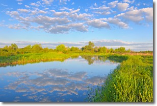
Weather Topic: What are Stratocumulus Clouds?
Home - Education - Cloud Types - Stratocumulus Clouds
 Next Topic: Stratus Clouds
Stratocumulus clouds are similar to altocumulus clouds in their
fluffy appearance, but have a slightly darker shade due to their additional mass.
A good way to distinguish the two cloud types is to hold your hand out and measure
the size of an individual cloud; if it is the size of your thumb it is generally
an altocumulus cloud, if it is the size of your hand it is generally a
stratocumulus cloud.
It is uncommon for stratocumulus clouds to produce precipitation, but if they do
it is usually a light rain or snow.
Next Topic: Stratus Clouds
Current conditions powered by WeatherAPI.com


