Weather Alert in Ohio
Special Weather Statement issued February 6 at 9:20PM EST by NWS Pittsburgh PA
AREAS AFFECTED: Tuscarawas; Carroll; Coshocton; Harrison; Jefferson; Muskingum; Guernsey; Belmont; Noble; Monroe; Allegheny; Washington; Greene; Westmoreland; Westmoreland Ridges; Fayette; Fayette Ridges; Indiana; Higher Elevations of Indiana; Hancock; Brooke; Ohio; Marshall; Wetzel; Marion; Monongalia; Ridges of Eastern Monongalia and Northwestern Preston; Preston
DESCRIPTION: A arctic cold front continues to drop across the region this evening. A band of moderate to heavy snow showers is accompanying the boundary. Visibilities of one-half mile or less and wind gusts to 40 MPH are possible in the heavier snow showers. A quick accumulation of one-half to one inch will be possible, especially on untreated surfaces. Snow Squall Warnings are already in effect for portions of this band, and more may be necessary for the heaviest showers that drop visibility to one- quarter mile or less in heavy, blowing snow. Motorists are urged to use caution while driving this evening. If you encounter heavy snow and very low visibility, slow down and increase the distance between your car and those that surround you. Consider delaying travel until the heavy snow showers have passed.
INSTRUCTION: N/A
Want more detail? Get the Complete 7 Day and Night Detailed Forecast!
Current U.S. National Radar--Current
The Current National Weather Radar is shown below with a UTC Time (subtract 5 hours from UTC to get Eastern Time).

National Weather Forecast--Current
The Current National Weather Forecast and National Weather Map are shown below.

National Weather Forecast for Tomorrow
Tomorrow National Weather Forecast and Tomorrow National Weather Map are show below.

North America Water Vapor (Moisture)
This map shows recent moisture content over North America. Bright and colored areas show high moisture (ie, clouds); brown indicates very little moisture present; black indicates no moisture.

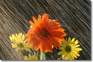
Weather Topic: What is Rain?
Home - Education - Precipitation - Rain
 Next Topic: Shelf Clouds
Precipitation in the form of water droplets is called rain.
Rain generally has a tendency to fall with less intensity over a greater period
of time, and when rainfall is more severe it is usually less sustained.
Rain is the most common form of precipitation and happens with greater frequency
depending on the season and regional influences. Cities have been shown to have
an observable effect on rainfall, due to an effect called the urban heat island.
Compared to upwind, monthly rainfall between twenty and forty miles downwind of
cities is 30% greater.
Next Topic: Shelf Clouds
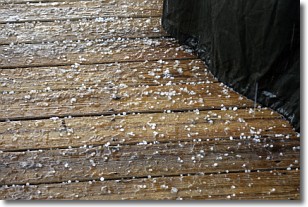
Weather Topic: What is Sleet?
Home - Education - Precipitation - Sleet
 Next Topic: Snow
Sleet is a form of precipitation in which small ice pellets are the primary
components. These ice pellets are smaller and more translucent than hailstones,
and harder than graupel. Sleet is caused by specific atmospheric conditions and
therefore typically doesn't last for extended periods of time.
The condition which leads to sleet formation requires a warmer body of air to be
wedged in between two sub-freezing bodies of air. When snow falls through a warmer
layer of air it melts, and as it falls through the next sub-freezing body of air
it freezes again, forming ice pellets known as sleet. In some cases, water
droplets don't have time to freeze before reaching the surface and the result is
freezing rain.
Next Topic: Snow
Current conditions powered by WeatherAPI.com


