Weather Alert in Iowa
Winter Storm Warning issued February 19 at 2:45PM CST until February 20 at 6:00AM CST by NWS Des Moines IA
AREAS AFFECTED: Webster; Crawford; Carroll; Greene; Boone; Audubon; Guthrie; Dallas; Cass
DESCRIPTION: Precipitation will spread from western into central Iowa this afternoon and evening. Initially, it may begin as a rain/snow mix across southern and western Iowa before changing to snow. A band of 5 to 8 inches of snow is expected by Friday morning from western through central to northeastern Iowa. There will be a sharp gradient of snowfall on either side of the heaviest band of snow. Snow rates may exceed 1" per hour at times this evening leading to rapid snow accumulations on roads and slick travel conditions. A small change in the location of the band could alter forecast snow amounts. * WHAT...Heavy snow expected. Total snow accumulations between 5 and 8 inches. * WHERE...Portions of western and central Iowa. * WHEN...Until 6 AM CST Friday. * IMPACTS...Travel could be very difficult. The hazardous conditions could impact the Thursday evening commute. Heavy snow with breezy winds could lead to isolated power outages.
INSTRUCTION: If you must travel, keep an extra flashlight, food, and water in your vehicle in case of an emergency. For the latest travel conditions, check the Iowa 511 app, www.511ia.org, or dial 511.
Want more detail? Get the Complete 7 Day and Night Detailed Forecast!
Current U.S. National Radar--Current
The Current National Weather Radar is shown below with a UTC Time (subtract 5 hours from UTC to get Eastern Time).

National Weather Forecast--Current
The Current National Weather Forecast and National Weather Map are shown below.

National Weather Forecast for Tomorrow
Tomorrow National Weather Forecast and Tomorrow National Weather Map are show below.

North America Water Vapor (Moisture)
This map shows recent moisture content over North America. Bright and colored areas show high moisture (ie, clouds); brown indicates very little moisture present; black indicates no moisture.

Weather Topic: What is Sleet?
Home - Education - Precipitation - Sleet
 Next Topic: Snow
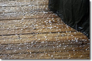
Sleet is a form of precipitation in which small ice pellets are the primary
components. These ice pellets are smaller and more translucent than hailstones,
and harder than graupel. Sleet is caused by specific atmospheric conditions and
therefore typically doesn't last for extended periods of time.
The condition which leads to sleet formation requires a warmer body of air to be
wedged in between two sub-freezing bodies of air. When snow falls through a warmer
layer of air it melts, and as it falls through the next sub-freezing body of air
it freezes again, forming ice pellets known as sleet. In some cases, water
droplets don't have time to freeze before reaching the surface and the result is
freezing rain.
Next Topic: Snow
Weather Topic: What are Stratocumulus Clouds?
Home - Education - Cloud Types - Stratocumulus Clouds
 Next Topic: Stratus Clouds
Stratocumulus clouds are similar to altocumulus clouds in their
fluffy appearance, but have a slightly darker shade due to their additional mass.
A good way to distinguish the two cloud types is to hold your hand out and measure
the size of an individual cloud; if it is the size of your thumb it is generally
an altocumulus cloud, if it is the size of your hand it is generally a
stratocumulus cloud.
It is uncommon for stratocumulus clouds to produce precipitation, but if they do
it is usually a light rain or snow.
Next Topic: Stratus Clouds
Current conditions powered by WeatherAPI.com


